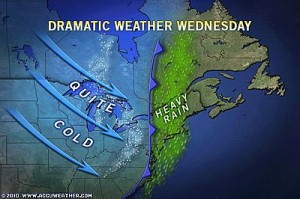
UNIVERSITY PARK – AccuWeather.com reports a storm set to deliver heavy rain and flooding problems Tuesday could bring a change to snow on the back end Wednesday in part of the Northeast.
It would be the last sort of thing to expect following the chaos associated with 1 to 3 inches of rain and flash flooding.
However, this very sort of thing is possible following the rain over the central and northern Appalachians and the eastern Great Lakes.
Enough snow could fall to coat not only windshields and grassy areas, but also roads and sidewalks.
The most likely area for the change to snow to happen stretches from the mountains of West Virginia and western Maryland to western and central Pennsylvania, western and northern New York, Vermont and neighboring Canada.
The timing of the changeover would begin early Wednesday morning in the south to late in the day and evening in the north.
The snow could hit during the morning drive Wednesday around Pittsburgh and Morgantown, W.Va.
It could also make for an interesting drive home Wednesday across upstate New York, where temperatures will drop off the fastest.
It is possible the snow would focus into a narrow, heavy band only lasting a couple of hours, but perhaps bringing an inch to some locations.
East of the Appalachians, from Richmond to Philadelphia, New York City and Boston, the rain is likely to simply end the traditional way… with a big push of dry air accompanied by gusty winds and clearing.
A change from rain to snow during a storm is a rare event. Sometimes you can go through an entire winter and never have such a phenomenon occur, as dry air usually arrives before the air is cold enough for snow.
By Alex Sosnowski, Expert Senior Meteorologist for AccuWeather.com


