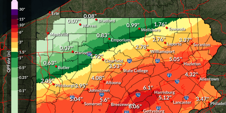
CLEARFIELD – Heavy rainfall associated with Tropical Depression Ida is expected to soon drench central Pennsylvania and put parts of the region at risk for flooding.
According to a National Weather Service – State College weather advisory, a flash flood watch is in effect from 8 a.m. Wednesday until 8 a.m. Thursday.
Excessive rainfall associated with Ida combined with pre-saturated conditions will result in an increasing likelihood of significant flash and urban flooding impacts in parts of the watch area.
Rainfall totals of three to five inches are forecast across south-central Pennsylvania with locally higher amounts up to seven inches possible.
Considerable river flooding is becoming more probable as several small streams are expected to reach minor to moderate flood levels in the Juniata and Lower Main Stem Susquehanna River basins.
According to the NWS advisory, a few points could crest above major flood stage with significant inundation flooding possible in adjacent areas.
Clearfield County Emergency Management Deputy Director Steven Smith said the county EMA has already pre-designated flood zones and been in contact with local EMAs in those areas.
Pre-designated flood zones include Osceola Mills, Chester Hill, Penfield and others, Smith said, adding “we will have a close eye on them” and should water levels rise, be ready to respond.
“Ida – like any other weather event we’ve had – is rapidly changing. So, prepare now; don’t wait until tomorrow (Wednesday) night.”
Smith said area residents should also be prepared for anything from minor basement flooding to a major flood event that requires evacuation.
He suggested residents clear their basement floor, find a place to safely store electronics and have necessities and a bag ready should they have to leave their home.
The most important thing is to “have a plan,” Smith said. “Stay informed … and if there’s a flood-related emergency, don’t hesitate to call 911. Call, and don’t wait until it’s too late.”


