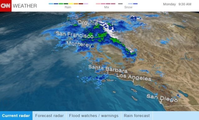
Residents of northern and central parts of California, already drenched by weeks of rain, prepared for possible flooding and landslides as another round of storms pummeled the state.
More than 14 million people are under a flood warning or flash-flood watch and residents have been advised to prepare for evacuations. Six to 10 inches of rain could fall from San Francisco eastward before the storm tapers off, CNN meteorologist Dave Hennen said Monday.
“Gather important items, documents and medications in a ‘go bag’ in case you need to evacuate quickly,” the National Weather Service in Sacramento said in an advisory. ” Don’t forget to plan for your pets, too. Make sure your vehicles have a full tank of gas.”
In Salinas, south of San Francisco, some evacuating residents had to be rescued by boat Monday, CNN affiliate KSBW reported. Other people in Monterey County have been waiting days for electricity to be restored.
“We’re on our 56th hour without power now and it’s getting a little brisk inside the house,” Gary Bolden of Prunedale told KSBW.
At the San Joaquin River Club, a private residential area east of San Francisco, residents have been patrolling the river levees and discussing possible evacuation routes, reported CNN affiliate KPIX.
“We have a levee response team, a sand bagging team, teams to check on what walkers checking on the levees find,” resident Paula Martin said. “Our community is pulling together like real champs.
Water was being released from the Anderson Dam in Morgan Hill, which was expected to cause downstream flooding, San Jose Mayor Sam Liccardo said on Facebook.
San Jose resident Ruben Lechuga told CNN affiliate KGO he hoped his local creek wouldn’t spill, adding, “But if it does, we just move out for a while and see what happens. It’s all we can do.”
The strong Pacific storm also is expected to bring howling winds and mountain snow to central and northern parts of California, the National Weather Service reported.
Meteorologists explain the current weather patterns by saying that as a condensed column of moisture moves inland, the water vapor sweeps over the mountains, cools and forms an “atmospheric river,” bringing heavy precipitation.
Strong southerly winds with gusts of 45 to 65 mph are expected to whip through the Central Valley and surrounding foothills.
The National Weather Service said the storms carry a threat of rock and mudslides, potentially making travel dangerous.
In Orinda, east of Berkeley, PG&E crews worked over the weekend to shore up a transmission tower threatened by a possible landslide, KGO reported. The tower is so remote, crews used a helicopter to transport some of their equipment.
Roads already closed or partially blocked by mudslides on Monday included northbound State Road 1 in Santa Cruz County and Sir Francis Drake Boulevard in Martin County, authorities said on social media.
The weather also appeared to affect air travel. Flightaware.com, a website that tracks airport traffic, reported 53 flight cancellations and 67 flight delays out of San Francisco International Airport as of noon (3 p.m. ET).
Deadly downpour
Northern California already is soaked from heavy rains that have pummeled the state since early January. More stress on levees, dams, rivers, creeks and streams is expected.
Officials are also keeping an eye on the Oroville Dam, after there were mandatory evacuations last week amid concerns an emergency spillway could fail and threaten communities. Authorities said Monday the water level in the lake is now 849 feet, the flood control stage normally maintained this time of year.
“Additional heavy rain will only make matters worse,” CNN meteorologist Derek Van Dam said. “There could be flooding in places that haven’t flooded in many years. The time to take action is now.”
The new onslaught of rain in Northern California comes as Southern California dries out following downpours that left five people dead.
“We’re effectively turning off the tap in Southern California but turning it right back up again across the northern and central parts of the state,” Van Dam said.
Storms smack Texas
Meanwhile, thunderstorms backed by racing winds set off a string of tornado warnings in parts of southeast Texas on Sunday and into Monday morning, according to the National Weather Service.
The strong storms, along with intensifying wind shears, produced two tornadoes midday Monday in the San Antonio area, the agency said on Twitter. One was rated EF-1 with 105 mph winds, and the other an EF-0 with 70 mph winds.
At least 100 homes were reported damaged late Sunday in San Antonio, the National Weather Service told CNN. Officials were sending out teams to survey losses.
Nearly 40,000 customers in the San Antonio area remain without power, CPS Energy said. Two minor injuries were reported, officials said.


