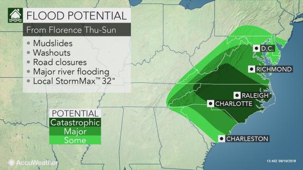
With the potential for Florence’s forward speed to slow and possibly stall, a current forecast of feet of rain would lead to catastrophic flash flooding and major river flooding in parts of the Carolinas, Virginia and possibly other neighboring states.
“Strength, track and forward speed of Florence will be the major players in determining the scope and amount of rainfall and correspondingly the severity of inland flooding,” according to AccuWeather Hurricane Expert Dan Kottlowski.
Brace for flooding on par with Floyd, Joaquin and other hurricanes
Even in lieu of the worst-case scenario, Florence has the potential to join the ranks of the costliest natural disasters in the history of the United States, joining Irma, Maria and Harvey in 2017; Sandy in 2012; Katrina in 2005 and Andrew in 1992.
In addition to storm surge flooding, inland flooding will escalate from urban and poor drainage areas to small streams. However, even as torrential rain ceases days after the initial first drops from Florence, some major rivers in the region are likely to reach major flood stage.
Some communities may be under water for days and possibly a week or more.
Download the free AccuWeather app to keep up with the latest information on the tropics and the potential for rain and flooding.
“Precautionary preparations for major flooding are advised,” Kottlowski said.
“People should expect not only travel disruptions, but also disruptions to daily activities related to work or school.”
Moving the most valuable items out of the basement and first floor onto the second floor in flood-prone areas may be of interest at this time. Locate important papers and photographs.
As the rain pours down during the storm, inland evacuations may become necessary and the time for completing such tasks will come to an end.
Have a plan of action in place ahead of the flooding. Work-at-home plans may not be an option in some communities where the power goes out or flooding commences. Without a means of power, computer and cell phone batteries will drain.
- RELATED:
Preparing for the costliest weather disaster in the US: How to stay safe before, during and after a flood
What you should do if you get stuck driving in floodwaters
Experts share tips on how to prepare children for hurricanes
Expert tips for preventing mold growth or remediating mold in your home after a flood
Strengthening Florence to pose serious threat to US East Coast later this week
Which areas are likely to be hit the hardest by inland flooding?
On Thursday, the first bands of rain directly associated with Florence will arrive on the Carolina and Virginia coasts. Rainfall will then spread inland and northward and intensify through Friday and during the weekend.
“At this time, the most likely scenario is for 1-2 feet of rain with a Local AccuWeather StormMax™ of 32 inches centered on portions of North Carolina and Virginia from Florence,” Kottlowski said.
“Torrential rain would still affect portions of South Carolina as well.”
This leading scenario assumes that Florence’s forward speed slows upon nearing the coast, but the storm continues to drift inland slowly.
A continued northwestward drift or curve to the north may cause heavy rain to fall and raise the risk of flooding farther north and west in Tennessee, West Virginia, Maryland and Pennsylvania this weekend.
A more extreme scenario suggests that Florence completely stalls on the coast or inland for days. In such a scenario, a number of locations may receive more than 2 feet of rain with perhaps some locations topping 3 feet from the coast to the Piedmont and southern Appalachians.
Is there a flooding risk in the mid-Atlantic, central Appalachians?
There is another scenario, where Florence may slow near the coast and crawl northward to some extent along the mid-Atlantic coast, Kottlowski stated.
In this case, areas as far north New York City and southern New England should monitor Florence’s track for strong winds and above-normal tides, let alone the risk of flooding from torrential rainfall.
Meanwhile, rain, partially associated with Tropical Rainstorm Gordon, will continue to drench some of the Northeast into Tuesday.
Were rain from Florence to overlap rain from Gordon, a mere several inches of rain this weekend could be enough to initiate stream and river flooding.
Some streams and rivers in parts of the Northeast are at major flood stage as of Monday morning following two or more days of steady rain. Up to 8 inches of rain have fallen on parts of Pennsylvania this past weekend, on top of what has been the wettest summer on record for a number of locations in the mid-Atlantic states.
Will areas south of the storm track be spared?
The heaviest and steadiest rain tends to focus north and northwest of a hurricane making landfall along the Atlantic coast.
At this time, it appears that Georgia and Florida is likely to be spared the risk of torrential rain and flooding from Florence. Only a track more to the west or west-southwest would cause that forecast to change.
Rain could wrap in and linger across part of mid- and upstate South Carolina even with a North Carolina or Virginia storm track.
Initially, sporadic showers and thunderstorms not associated with Florence are in store for the southern Atlantic region into Wednesday.
Most likely, dry air will sweep in across Georgia, Florida and part of South Carolina from the west as Florence either pushes inland over North Carolina and Virginia or hovers along the North Carolina and Virginia coasts.


