It’s October. A powerful hurricane is lashing the Bahamas. The whole system is threatening to head straight north to the United States.
You can’t blame the people along the East Coast if they’re having a Superstorm Sandy flashback when it comes to Hurricane Joaquin.
The powerful tropical system became a major hurricane overnight. On Thursday afternoon, it intensified to a Category 4 hurricane with maximum sustained winds of 130 mph, the National Hurricane Center said. And it was still holding strong a few hours later.
The good news: If current projections hold, Joaquin won’t be another Sandy.
The not-so-good news: Hurricane projections are notoriously unpredictable. And regardless of whether Joaquin makes landfall, it probably will cause plenty of rain and more flooding along an already soaked East Coast.
Joaquin hitting the Bahamas
Joaquin whipped parts of the Bahamas, an archipelago nation with more than 350,000 people, and the slow-moving storm is expected to continue pounding the islands through Friday.
As of 5 p.m. ET, the U.S. National Hurricane Center reported that the storm was centered about 15 miles northwest of Crooked Island in the Bahamas and 70 miles of San Salvador in the same island nation.
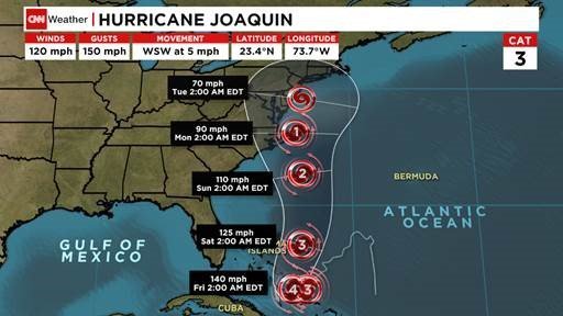
Forecasters say the hurricane — which, early Thursday evening, was moving southwest at 6 mph — will be near the northwestern Bahamas, including the country’s most populous city, Nassau, by Friday. That’s when the storm is expected to turn northward and began moving at a faster clip.
By that time, Joaquin could have 140 mph winds capable of causing catastrophic damage, the National Hurricane Center said.
Ten to 20 inches of rain could fall over much of the central Bahamas through Friday, according to the hurricane center.
Rain isn’t the only concern: Dangerous storm surges — with water levels as high as 5 to 10 feet above normal tides — are possible on the central Bahamian coasts.
Swells from Joaquin also will affect the southeastern U.S. coast, potentially creating life-threatening rip currents, the hurricane center said.
Outer rain bands could hit parts of Cuba, Haiti and the Dominican Republic through Friday, forecasters said.
Where it might make landfall in U.S.
Joaquin’s forecast track shows it could be near North Carolina by Monday and possibly New Jersey a day later, hauntingly close to where Superstorm Sandy made landfall in 2012.
It was just three years ago this month that Sandy slammed the Northeast, devastating parts of New York, New Jersey and Connecticut.
But the projected path of the current storm system already has changed multiple times and could change again.
And should Joaquin make it back to the areas Sandy devastated before, it’s not expected to pack the same punch.
How bad it’s likely to be
When Sandy made landfall on October 29, 2012, it had hurricane-force winds. Joaquin is projected to be a tropical storm once it gets that far north.
The rain? Now that’s a different story.
No matter where Joaquin goes, the storm is expected to bring significant rainfall to the East Coast, where some states already were dealing with flooding from separate systems this week.
“One way or the other, North Carolina, South Carolina, Virginia and on up will get between 5 and 10 inches of rain — even without a direct landfall,” CNN meteorologist Chad Myers said. “If we get a landfall, we get 15 inches of rain and winds of 80 mph.
“But without even a direct landfall, there will be significant flooding through the Carolinas, through Virginia, and all the way up the East Coast.”
Parts of the eastern U.S. from Florida to New Jersey were under flood watches and warnings Thursday morning, with more than 10 inches of rain already having fallen in some areas this week.
Flooding made some streets impassable in Portland, Maine, on Wednesday. Several cars were stalled on one street there after their drivers tried to make it through standing water, CNN affiliate WMTW reported.
Floodwater rose to the top of vehicles’ tires at a Whole Foods store in Portland, stranding drivers, WMTW reported.
How communities are getting ready
Coastal communities prepared for Joaquin’s expected weekend visit.
“The ground gets saturated, trees come down, there can be a lot of different issues,” Paula Miller with the Virginia Department of Transportation told CNN affiliate WAVY. “If the ground is so saturated that trees start coming down in the roadways, obviously that’s going to be one of the things that we’re going to be prepared to respond to.”
Virginia Gov. Terry McAuliffe and New Jersey Gov. Chris Christie declared states of emergencies.
On Wednesday morning, winds topped 20 mph along the Virginia Beach coast, with intermittent rain.
Along Virginia Beach’s Atlantic Avenue, a main thoroughfare about two blocks from the ocean, business owners appeared to be taking a wait-and-see approach. There were no boarded-up windows. Stores remained open, but there were only a few customers. It wasn’t clear if that was because of the weather or because it’s October in a beach town.
Asked what she was doing to prepare for Joaquin, Sharlotte Castillo of the beach shop Sunsations, about a block from the water, told CNN, “Pray, but we always pray, so nothing new. … We’re usually fine here — maybe a little rain, but we’re staying open.”
In eastern Pennsylvania, folks were taking the threat just as seriously. The Poconos took a beating during Sandy.
“What we’re expecting here is to be on alert for flash floods as well as power outages, and so we’re trying to get the word out to the community to think ahead, to have a plan,” Michele Baehr with the Red Cross told affiliate WNEP.
Dwyane Francis of Bushkill stocked up on canned goods.
“Preparation is the key. You have to be prepared for everything,” he said.


