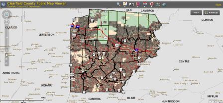
CLEARFIELD – Members of the general public now have access to an online map viewer and real estate data tool, announced John Kaskan, GIS coordinator, at yesterday’s workshop meeting of the Clearfield County Commissioners.
The county’s GIS office collaborated with the assessment office and IT department to develop the online map viewer application. It allows users to search many county dataset layers, including physical addresses; tax parcel information; flood zones; and emergency services, post office, school and government building locations; municipal boundaries; and voting precinct boundaries and locations.
The online map viewer application also features aerial photographs and topographic base-maps that are viewable on various datasets. However, the online maps and data are only for information and research purposes and cannot be presented in court, said Kaskan.
“The mission of the Clearfield County GIS Department is to provide up-to-date geographic information with information technology that allows users to immediately explore and analyze geographic data,” said Kaskan. “GIS involves using mapping software, hardware and databases in order to create, view and distribute geographic-related data.”
The county, Commissioner Mark B. McCracken said, wanted to make mapping and real estate data more available to the general public. He said users can now search mapping and real estate data for the entire county. “I think it’ll become a very useful tool,” he said.
The online map viewer application is free to the general public. It can be accessed either through the Clearfield County Government main Web site or the GIS Department Web Site. Users must have Adobe Flash Player 11 or greater installed on their computer; there is a link to a free download on the Web site.
Anyone with questions about the online map viewer application should contact the county’s GIS Department via e-mail at ccgis@clearfieldco.org or by phone at 814-765-2641, Ext. 5001.


