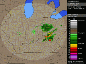
STATE COLLEGE – AccuWeather.com reports a cluster of thunderstorms progressing across northern Indiana and northern Ohio are igniting torrential downpours and flash flooding.
“The ground is hard as a rock since it has been so dry recently, so runoff can produce flash flooding very quickly,”AccuWeather.com Expert Senior Meteorologist Henry Margusity said.
The storms will continue to shift eastward across northern Pennsylvania later today, unleashing rainfall of up to 3 – 4 inches in some communities. Be alert for rapidly changing weather conditions with sudden downpours developing.
Never drive through a roadway with water over it, since water could be rapidly rising with flash flooding.
Meanwhile, south of the storms producing flooding rainfall, severe thunderstorms will erupt from the Ohio River Valley into the mid-Atlantic. Thunderstorms could strengthen over southern Illinois, southern Indiana, southern Ohio and northern Kentucky over the next few hours.
Later on as daytime heating adds more instability to the atmosphere, communities from southeastern Missouri to Maryland could have more damaging winds and large hail for areas already pounded on Wednesday.


