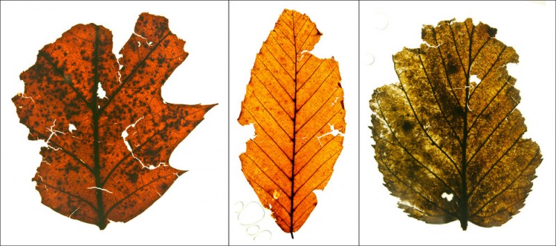
UNIVERSITY PARK – Sediment behind milldams in Pennsylvania preserved leaves deposited just before European contact that provide a glimpse of the ancient forests, according to a team of geoscientists, who note that neither the forests nor the streams were what they are today.
“Milldams were built from the late 1600s to the late 1800s in Pennsylvania and other parts of the east,” said Peter Wilf, professor of geosciences, Penn State. “We can’t get information from historic records on what the area looked like before the dams because recording of natural history didn’t really begin until the 1730s and was not detailed.”
U.S. census shows that by 1840, tens of thousands of milldams existed in the mid-Atlantic region. About 10,000 of these were in Pennsylvania. In Lancaster County, estimates were one dam for every mile of stream. The abundance of dams in the area altered the landscape dramatically, according to the researchers.
“I see a potential modern day benefit for this research,” said Sara J. Elliott, recent Penn State master’s degree recipient, currently a research scientist associate at University of Texas Austin, Bureau of Economic Geology. “Attempts to restore precontact environments have been unsuccessful when the effects of milldams were not considered. Understanding the past forest makeup may provide a way to help get a successful and useful reconstruction.”
The researchers looked at samples of 300-year-old leaves buried by sediment that backed up behind Denlinger’s Mill in Lancaster County. The leaves came from trees on an outcrop above the dam. Because sediment quickly covered the leaf layer, the leaves that date from before the dam remain intact. When carefully separated and cataloged, the leaves reveal the makeup of the forest near the water’s edge before milldams were built and forests were cleared. The researchers published their findings in today’s (Nov. 13) issue of PLOS ONE.
Dorothy J. Merritts, chair, Department of Earth and Environment and Harry W. and Mary B. Huffnagle Professor of Geoscience, and Robert C. Walter, associate professor of geosciences, both of Franklin and Marshall College, who found the fossil leaf mat note that the Denlinger’s Mill site was our ‘Eureka’ moment in the unraveling of this anthropogenic impact story.”
“We expected to see evidence for single stream channels that meandered back and forth across the valley bottom landscape for millennia, ” they wrote. “Instead, we found that most of the valley bottoms at the time of European contact were dominated by wetland ecosystems with numerous small, stable ‘anastomosing’ streams.”
These branching and reconnecting streams were far different from the steep-banked meandering streams that, since the dams were breached, now cut through the silt deposits created by the dams.
“First we had to uncover the leaf mats and then try to get a sample,” Elliott said. “The mats were fragile and delicate, and getting them back to the lab or just transferring them from one container to another was problematic.”
Elliott carefully peeled away the leaves, stacked on top of each other in sticky mud and preserving gorgeous detail, to preserve as many pieces as possible. She then treated them in a variety of chemical baths, mounted them between large glass slides and cataloged their species.
“We got a lot of information that was not available from other sources,” said Elliott.
The Denlinger’s Mill site is unusual because of the rock outcrop and the trees that grow and grew there over the water. The leaves found in the stream bank preserve a snapshot of the trees growing directly above before European settlement, which Elliott then compared to the modern forest makeup.
The researchers found that the precontact forest was overwhelmingly American beech, red oak and sweet birch, similar to modern red oak/beech forests today. But box elder and another maple dominate the current forest that grows above the stream.
“It was intriguing to see samples from American chestnut, which isn’t around anymore because of the chestnut blight,” said Elliott. “On the whole though, the species are around today, just in different proportions and places.”
The researchers think that reconstructing landscapes more along the lines of those that actually existed before the 1700s might be a more successful approach to restoration. Establishment of precolonial-like habitats might also decrease the amounts of nutrients from the legacy sediments that currently flow into the Chesapeake watershed and cause increased algal and plant growth.
“We now know that legacy sediment from the stream banks caused by the milldams is the major source of eutrophication in the Chesapeake area,” said Wilf. “Not, as is usually assumed, modern agricultural runoff.”
