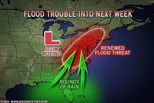
STATE COLLEGE – AccuWeather.com reports in the East, the cumulative effect of rounds of new, drenching rain spanning Thursday into next week may lead to renewed flooding problems.
While another steady, “fire hose” of rain similar to that of Irene in Vermont and upstate New York, or Lee in Pennsylvania and the southern tier of New York does not appear likely, the risk of flooding with this event should be take seriously.
According to Long Range Weather Expert Paul Pastelok, “The pattern will bring up to several rounds of heavy rain to some locations.”
The I-95 swath from Philadelphia to New York City has received over 2 feet of rain during the past seven weeks. Essentially this is over six months’ worth of rain.
According to Chief Operating Officer and meteorologist Evan Myers, “With 26.35 inches of rain in Philadelphia since Aug. 1, these are already the wettest back-to-back months in the city.”
New York City has received 24.36 inches for the same period as of midday Sept. 20.
That is only a small sample of a much larger rainfall problem.
Places that have received from 1 to 2 feet of rain during the period from Aug. 1 through Sept. 20 include Allentown, Harrisburg, Lancaster, Reading, Williamsport, Wilkes-Barre/Scranton in Pennsylvania; Albany, Binghamton, Islip and Poughkeepsie in New York; Baltimore, Hagerstown and Salisbury in Maryland; Washington, D.C.; Richmond, Va.; Dover and Wilmington, Del.; Newark, Newton and Trenton in New Jersey; Bridgeport and Hartford in Connecticut; Providence, R.I.; and Springfield and Worcester in Massachusetts.
Dozens of other locations can be added to this list.
The problem is there is more rain coming.
Weighing in the rainfall from August and September thus far, even a mere several inches of rain can bring small streams to bank full.
There is a possibility of upwards of 3 inches in some areas, not only during a several-day period, but perhaps in a matter of hours on more than one day.
The pattern Thursday into next week favors rounds of rain and thunderstorms, with excessive rainfall in some locations from the southern mid-Atlantic to New England.
According to AccuWeather.com Chief Meteorologist Elliot Abrams, “We cannot say for sure which areas will be hit the hardest with the upcoming rainfall, because the clusters of showers and thunderstorms we are concerned about have not formed yet.”
A southerly flow of air at most levels of the atmosphere will funnel in not only Gulf of Mexico moisture, but also Atlantic and tropical Atlantic moisture.
The pattern will become too much for drainage systems in some communities, streams and perhaps rivers to handle.
“So far there does not appear to be any major tropical intervention, such as another Irene or Lee, but even a much weaker, no-name system can lead to big problems,” Abrams added.
Abrams is concerned that even a single cluster of thunderstorms could be enough to bring about serious flooding issues.
The pattern has significant potential to cause flash, urban and small stream flooding.
Officials are urged to stay on top of the situation on a daily, if not hourly, basis due to the risk of last-minute drenching thunderstorms.
The cumulative effect of the rainfall over several days will have major rivers in the region on the rise again.
The possibility of another river flooding event like that of earlier in the month, though unlikely, cannot be completely ruled out because of recent prior rainfall.
By Alex Sosnowski, Expert Senior Meteorologist for AccuWeather.com